|
|
|
Two of Nature's Most Destructive Forces.
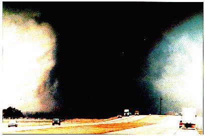
Tornadoes come from the energy released in a thunderstorm. As powerful as they are, tornadoes account for only a tiny fraction of the energy in a thunderstorm. What makes them dangerous is that their energy is concentrated in a small area, perhaps only a hundred yards across. Not all tornadoes are the same, of course, and science does not yet completely understand how part of a thunderstorm's energy sometimes gets focused into something as small as a tornado (but see "5" below).
Whenever and wherever conditions are right, tornadoes are possible, but they are most common in the central plains of North America, east of the Rocky Mountains and west of the Appalachian Mountains. They occur mostly during the spring and summer; the tornado season comes early in the south and later in the north because spring comes later in the year as one moves northward. They usually occur during the late afternoon and early evening. However, they have been known to occur in every state in the United States, on any day of the year, and at any hour. They also occur in many other parts of the world, including Australia, Europe, Africa, Asia, and South America.
The damage from tornadoes comes from the strong winds they contain. It is generally believed that tornadic wind speeds can be as high as 300 mph in the most violent tornadoes. Wind speeds that high can cause automobiles to become airborne, rip ordinary homes to shreds, and turn broken glass and other debris into lethal missiles. The biggest threat to living creatures (including humans) from tornadoes is from flying debris and from being tossed about in the wind. It used to be believed that the low pressure in a tornado contributed to the damage by making buildings "explode" but this is no longer believed to be true.
The answer to this depends on what is being measured ... the easiest way to answer this is by the size of the damage path. Also, it is important to note that the "average" can be misleading, since most tornadoes are small ... a simple average puts too much emphasis on the infrequent large events. A way around this is to use what is called the "median" to represent what is typical. The typical tornado damage path is about one or two miles, with a width of about 50 yards. The largest tornado path widths can exceed one mile, and the smallest widths can be less than 10 yards. Widths can vary considerably during a single tornado, because the size of the tornado can change considerably during its lifetime. Path lengths can vary from what is basically a single point to more than 100 miles. Note that tornado intensity (the peak windspeeds) is not necessarily related to the tornado size ... bigger is not necessarily stronger!
Detailed statistics about the time a tornado is on the ground are not available. This time can range from an instant to several hours ... what is typical is roughly 5 minutes or so.
As with tornado duration, detailed statistics about forward speed are not available. Movement can range from virtually stationary to more than 60 miles per hour ... what is typical is roughly 10-20 miles per hour.
The movie TWISTER was based upon work NSSL did in the mid-1980's using a 55-gallon drum filed with various meteorological sensors. It was called TOTO (TOtable Tornado Observatory). NSSL tried for several years to put it in the path of an oncoming tornado, but had minimal success. It did not have the sensors that fly up into the tornado, like in the movie. However, that is not a bad idea and with the advances being made in computer technology, we might be able to do that someday. |
The Fujita Scale is used to rate the intensity of a tornado by examining the damage caused by the tornado after it has passed over a man-made structure. |
||
| F Scale Number | Wind Speed (MPH) | Type of Damage Done |
| 40-72 | Some damage to chimneys; breaks branches off trees; pushes over shallow-rooted trees; damages sign boards. | |
| 73-112 | The lower limit is the beginning of hurricane wind speed; peels surface off roofs; mobile homes pushed off foundations or overturned; moving autos pushed off the roads; attached garages may be destroyed. | |
| 113-157 | Considerable damage. Roofs torn off frame houses; mobile homes demolished; boxcars pushed over; large trees snapped or uprooted; light object missiles generated. | |
| 158-206 | Roof and some walls torn off well constructed houses; trains overturned; most trees in fores uprooted. | |
| 207-260 | Well-constructed houses leveled; structures with weak foundations blown off some distance; cars thrown and large missiles generated. | |
| 261-318 | Strong frame houses lifted off foundations and carried considerable distances to disintegrate; automobile sized missiles fly through the air in excess of 100 meters; trees debarked; steel re-inforced concrete structures badly damaged. | |
| 319 + | Most information about the Fujita Scale and Tornadoes only go to an F5. Only a couple sites on the net I found list an F6 or F6 to F12.These winds are very unlikely. The small area of damage they might produce would probably not be recognizable along with the mess produced by F4 and F5 wind that would surround the F6 winds. Missiles, such as cars and refrigerators would do serious secondary damage that could not be directly identified as F6 damage. If this level is ever achieved, evidence for it might only be found in some manner of ground swirl pattern, for it may never be identifiable through engineering studies | |
and What They Mean |
TORNADO WATCH | Tornadoes are possible in your area. Remain alert for approaching storms. |
| TORNADO WARNING | A tornado has been sighted or indicated by weather radar. If a tornado warning is issued for your area and the sky becomes threatening, move to your pre-designated place of safety. |
| SEVERE THUNDERSTORM WATCH | Severe thunderstorms are possible in your area. |
| SEVERE THUNDERSTORM WARNING | Severe thunderstorms are occurring. |
|
Hurricanes need an ocean with water temperatures in the low to mid 80s (F), or warmer, to supply the warm moist air that fuels the clouds. They also need a way to flow the air toward the center (convergence) at low levels and remove the air aloft (divergence). When these conditions occur, pre-existing disturbances of many types can begin to organize into a tropical depression, then a tropical storm, then a hurricane.
In the North Atlantic Ocean, the classic mid-summer pattern for hurricane formation is in the low-level easterly trade-wind region from 10 to 20 degrees latitude north of the equator. Here, disturbances move westward from Africa several times a week that have the potential to strengthen. Before and after the mid-summer season, hurricanes form in the Gulf of Mexico, southern Caribbean Sea, and in the west Atlantic where several types of weather systems can form the necessary pattern of low-level inflow and upper-level outflow.
Hurricane damage is due to both wind and water. The more commonly visible damage is from wind, which can be devastating to buildings and vegetation. Torrential rains can cause devastating flooding and mud slides, especially in areas with hills or mountains. However, the largest losses of life and greatest damage are more often due to the storm surge and high water levels. The shape of the coastline, and the slope of the underwater ocean floor near the coast, influence how the storm surge from an approaching storm will affect the water that comes onshore. This storm surge, trapped in a cove or bay (not a wall of water), raises the level of the ocean along the shore up to 10 or 20 feet higher than normal. On top of the storm surge can be waves up to 40 feet high. Hurricane Andrew in south Florida was unusual in that most of its billions of dollars in damage was due to wind.
Hurricanes produce tornadoes, which add to the hurricane's destructive power. Tornadoes of this type most often occur in thunderstorms embedded in rain bands well ahead of the center of the hurricane in the right front quadrant. In September 1999, the City of Hampton was the victim of a tornado with Hurricane Dennis, but the center of the storm had not yet made landfall in central North Carolina. Tornadoes associated with hurricanes are typically weaker than those associated with severe thunderstorms, but the more intense the storm is, the threat of tornadoes is higher. Typically, the National Weather Service will issue a Tornado Watch well ahead of the forecast track.
|
Hurricanes are ranked from one to five on the Saffir-Simpson scale of strength, devised by H.S. Saffir, a design and construction engineer, and R.H. Simpson, a former director of the National Hurricane Center. |
|
| Catagory Number | Remarks |
| Category 1 | Central pressure of 28.94 inches or more and sustained wind of 74 to 95 mph, is accompanied by a 4- to 5-foot storm surge and causes minimal damage. |
| Category 2 | Pressure 28.50 to 28.93 inches, sustained wind of 96 to 110 mph, storm surge 6 to 8 feet, moderate damage. |
| Category 3 | Pressure 27.91 to 28.49 inches, sustained wind of 111 to 130 mph, storm surge 9 to 12 feet, extensive damage. |
| Category 4 | Pressure 27.17 to 27.90 inches, sustained wind 131 to 155 mph, storm surge 13 to 18 feet, extreme damage. |
| Category 5 | Pressure less than 27.17 inches, sustained wind of 155 mph, storm surge higher than 18 feet, catastrophic damage. |
| There is no category 6 because so few storms would reach that scale. | |
 |
Tornadoes And Hurricanes |